
Land forming
Why?
I'm massaging the land for three reasons:
- to guide water for infiltration, irrigation, and erosion control
- to smooth the land contours for easy maintenance
- to plant crops that can use the water
Water control structures

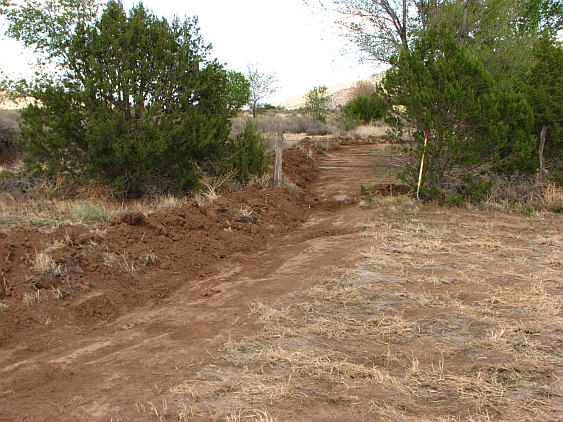
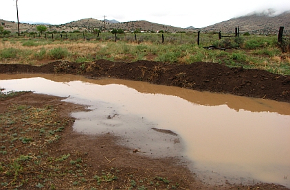
Water from the S => N slope on which Magdalena lies runs along First St. to the E and falls off into my driveway, where it used to erode a gully on its way to the N end of the property. The image shows the top end of this gully, but it got worse as you descended the driveway. The previous owners' response to this behavior was to fill in the gully with soil every year. Like a lot of people, they thought of rainwater as an annoyance rather than a resource.
Where did the water go? Some of it sank into the soil and some ran off into roads and arroyos to the north. I thought it would be more sensible to catch it and let it infiltrate into the ground and/or water native plants, or even fruit trees. Ideally it would be retained further upslope, but that will take some organization in the village, and won't happen for some years. So I decided to catch the run-on water in basins.
In May 2013 I engaged my neighbor, who has a Bobcat, to dig out two basins.


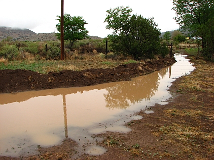
In the bottom image, the basins have filled (after a hard 1/2-hour rainstorm) and water is leaking through a breach in the lower berm. We need a higher spillway (I build them out of concrete rubble, as shown) and at least one more basin to catch all of the water. Also, the channel across the driveway routinely overflowed and water ran down past the cottage. These observations showed that we get a lot of water, and need to think of ways to control and use it.


In spring 2014, considering the overflow shown above, I built a third basin. This would surely catch all the water that escaped the upper two. No hurry, I thought, to build a spillway. Then in August we got our first good rain of the year, 2". The new basin filled up and ruptured, with all the water washing down across the field and my pollinator/grass plantings. Lesson: build at least one spillway, and if more are built, build them at the same elevation.
But then I reflected: why capture water in basins anyway? That was just a temporary control measure. What we really want is to use the whole field to store it, and use some of the stored water for growing trees. So in October 2014 laid out some contour lines with 6" fall across the field and pushed up berms out of swales. The result shows up clearly in this January shot.
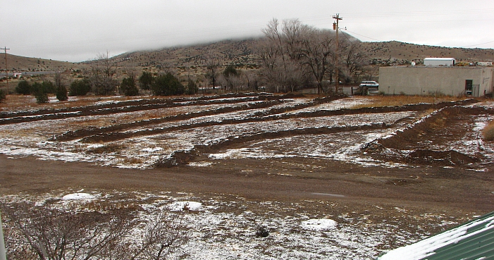
The first big rain washed gaps in a couple of these berms, so the contouring wasn't perfect and they need building up. I've planted some shrubs (from NM Forestry) on top of the upper berms and Nanking cherry from the same source along the lower (northern) berms. From above, the S half of the property looked like this in spring 2017.
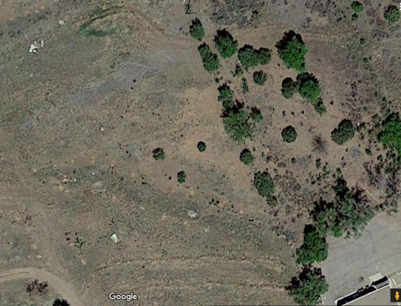
The water from the S side of Hwy 60 goes through a culvert into the post-office parking lot and flows around behind the PO into a shallow grassy basin, where it infiltrates. The postmistress, who's my cottage tenant, suggested that I could divert the water onto my land. Of course it's not her land (the PO rents it from a landowner), but when I couldn't reach the owner by mail, I went ahead and built a diversion ditch, partly on their property and partly on mine. This shot looks E to the original basin—note the fence spanning the ditch.
Here's how it looked after 0.5" of rain on May 13, 2015,
and here's how the detention basin looked. This view is approximately NW. It worked!
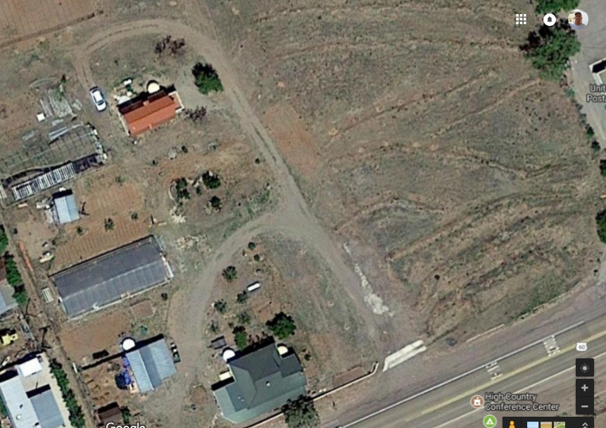
From above, the diversion looked as shown at top of the Google Maps image below, taken in Apr 17.
I'm hoping that the soil around the basin will remain damp for months, if not all year, a couple of feet down.
In spring 2017 I planted a few Ponderosa pine seedlings N of the berm and in October 2017, eight more on the grassy land just S of the basin. These are being drip-irrigated until they can exploit the soil water with strong root systems.
Back to November 2013. We built a flow channel across the driveway to direct the highway runoff into the SE field instead of letting it run down the driveway.


The channel is of 6" concrete with very little reinforcement (just a leftover piece of steel mesh under one of the sections), laid over compacted soil and butting into the asphalt on both of the long sides. The lower end will be protected with rubble to prevent undercutting by water.
Contouring
In late October 2013 I bought a 23-hp John Deere subcompact tractor with loader, rotary cutter, and post-hole digger attachments. The cutter was used to knock down the weeds, saltbush, and chamisa that obscured much of the middle section of the property, including the parts for a steel building that I've sold to someone who plans to pick it up soon. Reggie, who did much of the remodeling work on the cottage and built the flow channel, came with a chainsaw and cut down all of the elm saplings, which we piled up for chipping. We also cut down all but one of the large elm trees (see page Tree care for that story).
Then I started to grade the dropoffs (railroad embankments), with the intention of making them more gradual and easier to mow in coming years. I also dug out a seep just N of the cottage, where water stood on the surface year round, hoping that the hole would fill up. It didn't, though the soil stayed wet, so I filled it back in and will plant fruit trees near it.


Previous residents had dumped household trash and a variety of junk along the railway roadbed that runs through the property. (I haven't been impressed by the environmental conduct of the previous residents). With Jimmy Collins, visiting from Denver in January 2014, we hauled most of the trash to the transfer station and I sold around a ton of scrap iron in Socorro. I'm still picking up spikes and other metal scrap. The ground sloping up to the roadbed has now been graded, although it's hard to judge the slope in the shot below. Although it's still full of trash scraps, bricks, and other waste, I plan to stabilize it by planting pollinator plants [Note fall 2017: this didn't work, as the rain didn't cooperate].

Other earthworks for water control
Around here there are other earthen and stone structures for detaining water. The left-hand image below shows an arroyo-prevention system of berms on someone's ranch in the E foothills of the Magdalenas. The right-hand one shows rows of rocks that appear to have been placed by some rancher to slow sheet runoff. This is a view from Hwy 60 just E of South Canyon (visible in the photo), with the Magdalenas in the background.


Just E of Magdalena is a big arroyo (named E) with at least three check dams across it.

Active erosion is taking place in the Magdalenas and San Mateos. It isn't always apparent whether the cause is denudation of upper slopes by fire, hard rainfalls alone, or roads that were constructed without sufficient means of avoiding watercourses (which is sometimes impossible in narrow canyons) or shedding water (often requiring expensive culvert work).
